
In the 1970s, Sámi artist and activist Hans Ragnar Mathisen (Elle-Hánsa) started creating maps of Sápmi, the name of the Sámi people’s traditional lands on the Scandinavian Peninsula. Not only was he ignoring many of the traditional borders and boundaries of Norway, Sweden and Finland, Mathisen was also including on his maps Sámi names that had been excluded, renamed or otherwise lost to history. He was reclaiming his lands, even if only on paper.
Mathisen was not the first Indigenous artist to “decolonize the map,” but his cartographic activism would show other artists what was capable with art, maps and the names that are used for places all around the world.
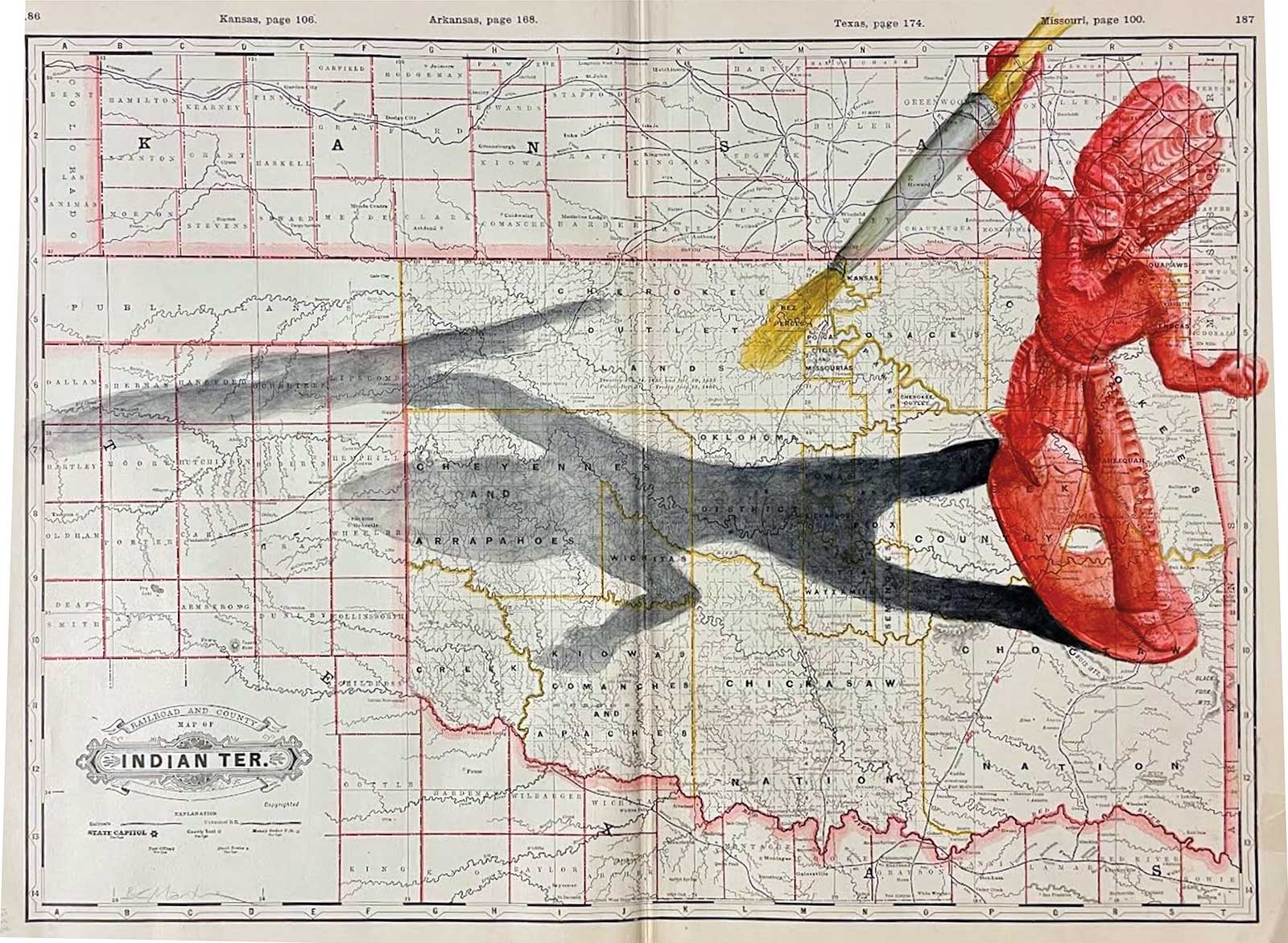
Bobby C. Martin (Muscogee (Creek)), Clyde on the Move in Indian Territory #2, on Cram’s 1888 map of Indian Territory, 16 x 22”
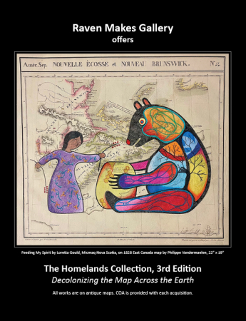
This concept is being taken to a thrilling new level with an exhibition opening virtually on March 25 and in-person on May 11 at Raven Makes Gallery in Sisters, Oregon. Now in its third year, The Homelands Collection will feature antique maps with new drawings, paintings and other artwork by Indigenous artists from around the world. The artists’ works often recontextualize the maps within a Native American perspective, which adds a fascinating component to the collection.Chris Morin, director and co-owner of Raven Makes Gallery, says he’s seen North American maps from both ends of the spectrum: maps that acknowledge Native American people and places, and then maps that include barely any references to the original inhabitants of the lands. “It’s really all over the place. Some map publishers were cranking maps out to make a buck so their maps are less accurate, and then others were much more serious about capturing the geography of the earth,” he says. “The worst ones are the maps that have racist terms. Some mapmakers would just use the wrong words. I’ve seen maps with things like ‘Mosquito Indians,’ ‘Dog Indians’ and ‘Quarrelsome Indians.’ Mapmakers would just slap anything on these maps. So for these artists to put a different story on them is really exciting.”
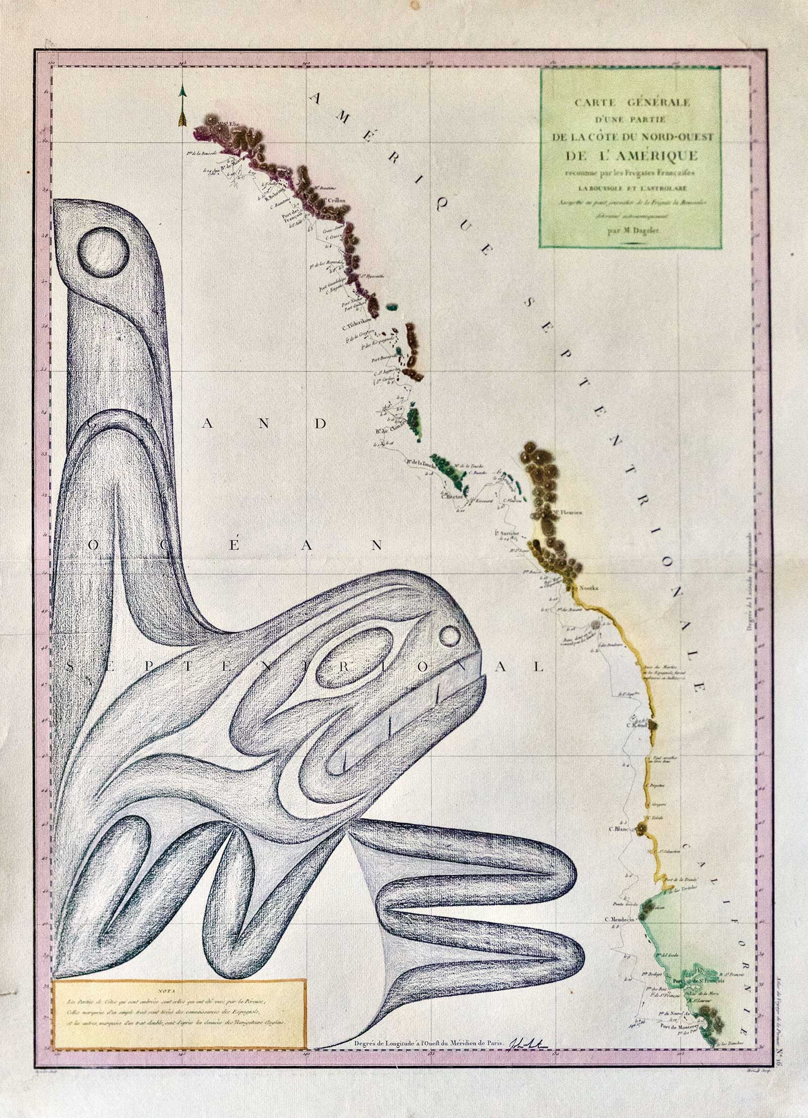
John Marston (Coastal Salish), Salish Sea Killer Whale, on La Perouse’s 1797 map of Western United States, Canada and Southeast Alaska, 27 x 19”
The idea for the exhibition came about in the middle of the pandemic, as the Oregon governor closed many of the non-essential businesses to reduce the spread of Covid-19. “I wish I could say it was a stroke of brilliance, but it really just came to be because we were living in that strange time. During the lockdown I had come across this amazing antique map. It was gorgeous and from the 1850s and [had] a lot of the tribes identified in it,” Morin says. “I gave it to Terrance Guardipee to see if he could do some artwork on it. It really all started right there. It took a full year to get it started, including learning about antique maps.”Morin, who calls the map works a subgenre of ledger art, started acquiring historic and antique maps, many from Europe, where antiquarians would deal in original maps from basically the entire history of mapmaking, including North American maps from as early as the 15th century. “Most maps of America, at least those made before 1810, were being made in Europe, which is why that’s the place to look for those maps now,” he says. “There are basically like five dealers in the United States that deal in the kinds of maps I was looking for. I want the best pieces, including ones that could have their authenticity verified—I wanted first-rate maps.”
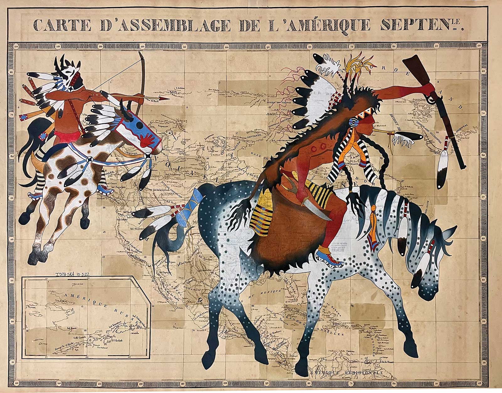
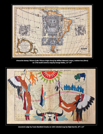
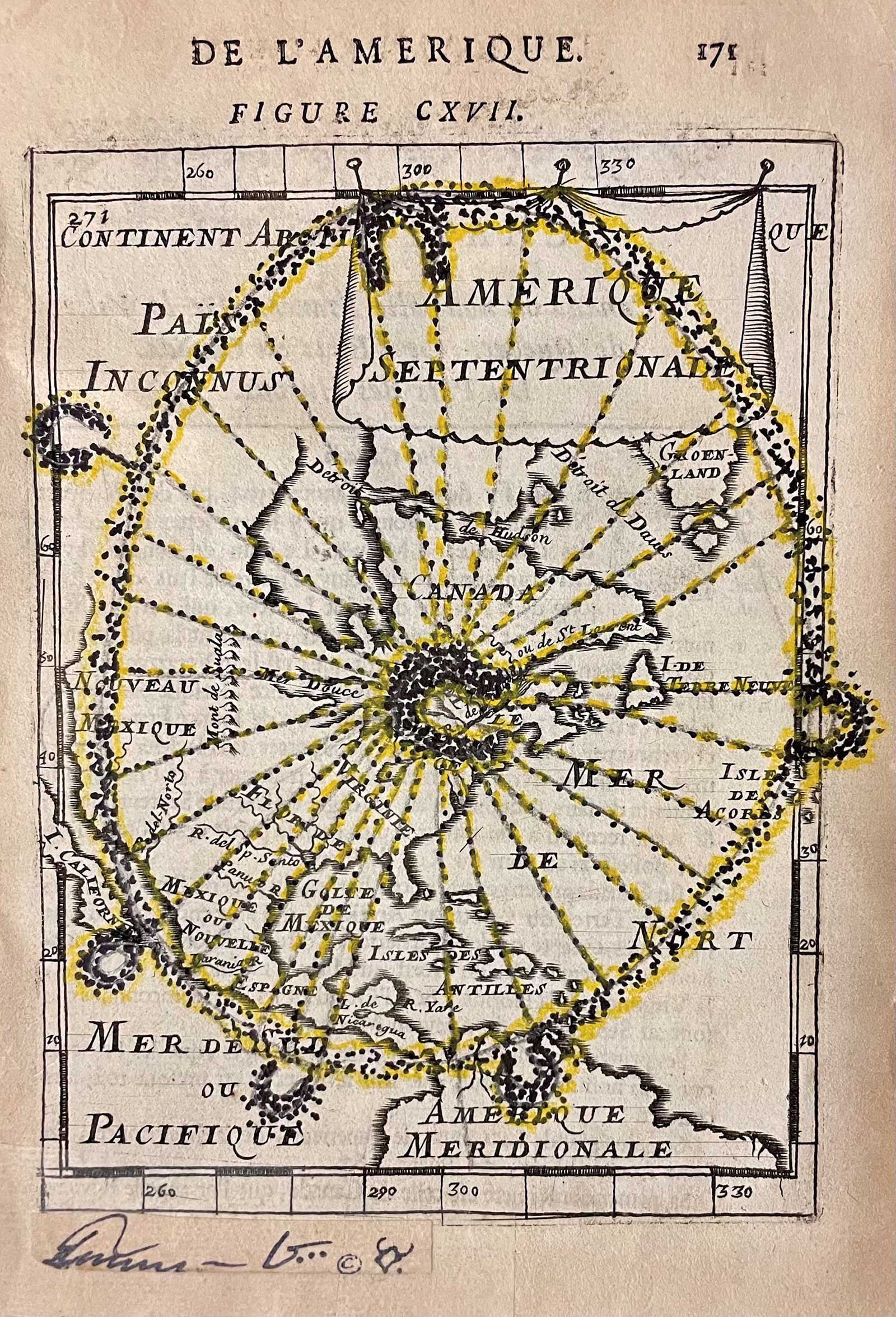
Travis Blackbird (Omaha), Warriors Heart, on Vandermaelen’s 1827 Key Sheet map of North America, 20 x 25”
And he found first-rate maps. A lot of them. Some were easier to acquire than others. For example, John Wesley Powell, who led expeditions into the Rocky Mountains and down the Colorado River, had maps printed for the Bureau of Ethnology, where he was the founding director. Those maps, all produced in the late 1800s, can be acquired for as little as $40. Other maps would cost hundreds or even thousands of dollars. Morin and his wife, LaRita, curator and co-owner at Raven Makes Gallery, were buying so many maps they were getting bulk discounts from top dealers.After acquiring a collection of maps, the Morins started giving them to artists for The Homelands Collection. They told the artists to create a new work from the maps—there were no restrictions or limitations.
“We started looking for maps that would pair nicely with certain artists. For instance, Terrance [Guardipee] is Blackfeet from Montana, so I would try to pair him with a map that would focus on that area. Other maps were celestial maps, which would show the stars from a certain location, so we could give those to artists that would have connections to those places,” Morin says. “Some of them were reluctant, but once the artists started getting the maps the reactions were really positive. Many of them talked about how emotional the maps made them feel. And then they get inspired.”
Terrance Guardipee (Blackfeet), Gift to the Sun, on Mallet’s 1683 map of North America, 6 x 4”
For the first two years of the show, the Morins would cautiously reveal their intentions with their map purchases since they were unsure how their map dealers would react to important maps being drawn and painted on. That all changed once major institutions started buying from The Homelands Collection. The Newberry Library of Chicago acquired three pieces. Harvard University, which has the nation’s oldest map collection, acquired four pieces. And the University of Southern Maine bought two. “That changed everything,” Chris says. “Now I can tell them what we’re doing and what institutions have been interested in the work.”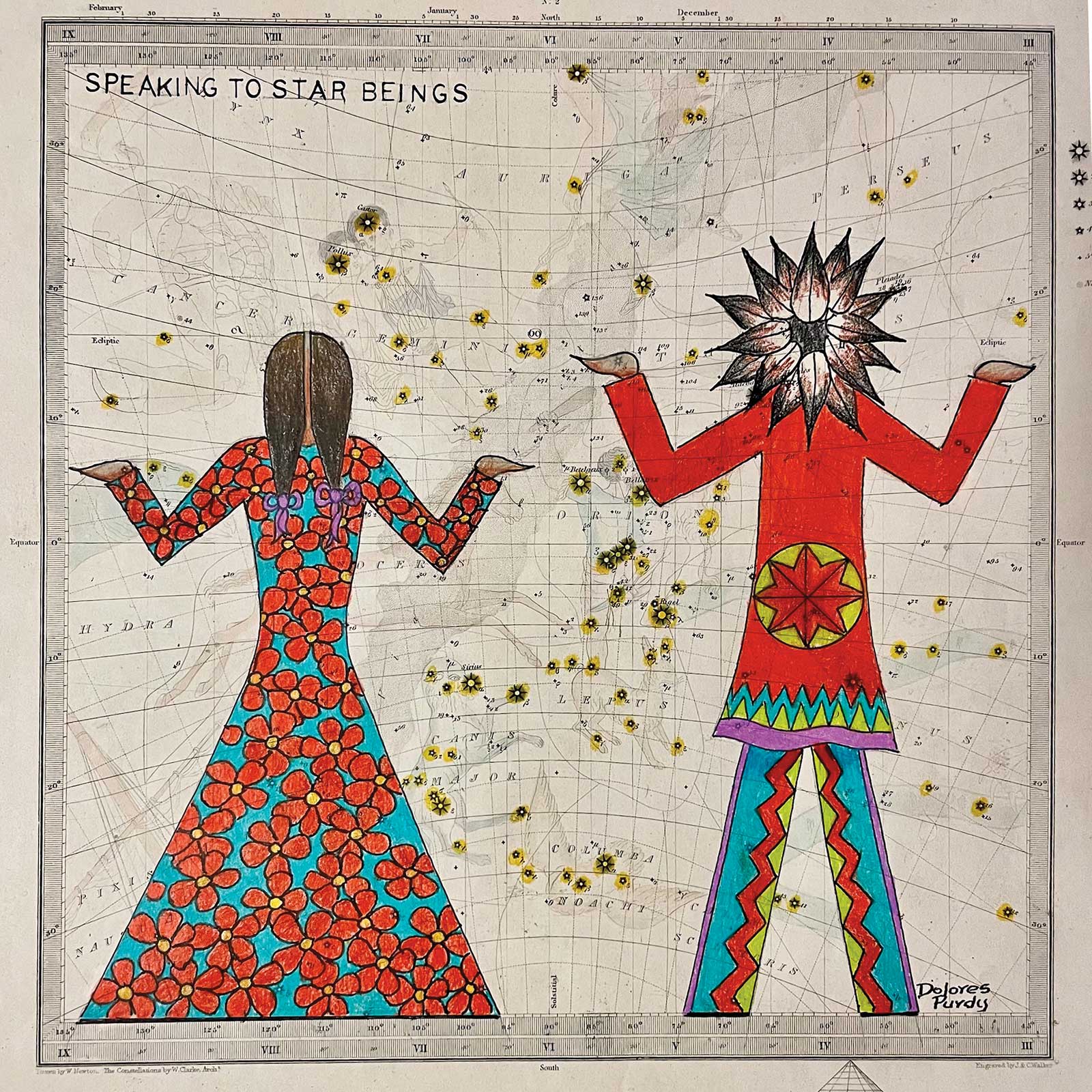
Dolores Purdy (Caddo Nation Winnebago), Speaking to Star Beings, on SDUK’s 1846 Celestial map, 10 x 11”
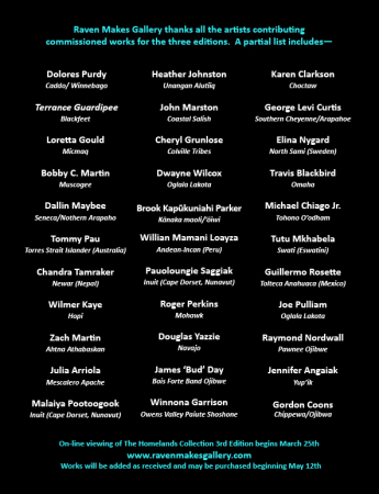
Artists for this year’s exhibition include Guardipee, John Marston (Coastal Salish), Heather Johnston (Unangan Alutiiq), Dolores Purdy (Caddo Nation), Travis Blackbird (Omaha), Karen Clarkson (Choctaw), Bobby C Martin (Muscogee (Creek)), George Curtis Levi (Southern Cheyenne/Arapaho), Wilmer Kaye (Hopi) and many others, including Indigenous artists from around the world.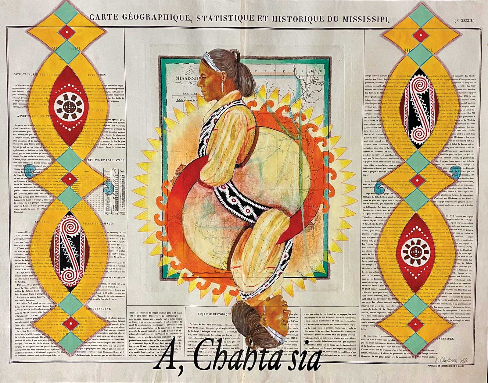
Karen Clarkson (Choctaw), A, Chahta Sia (Yes, I Am Choctaw), on Buchon’s 1825 map of Mississippi, 19 x 25”
Artwork includes Purdy’s Speaking to Star Beings on an 1846 celestial map. “Chris and LaRita are masters at selecting some amazing maps for this collection of works. This one of the celestial map dated 1846 is such a beautiful map printed upon hand-pressed cotton paper of the highest quality with a bit of tooth on the surface. It’s so wonderful to work upon and run my hands over the paper. Although I must admit, I often feel a twinge of guilt using these wonderful maps to draw upon. I have to keep telling myself, ‘There are many more maps out there and it is OK.’ Before I work on a map I really examine it to see if there are any places or names I want to keep in the background to add interest to the piece and be aware of what I cover with color,” Purdy says. “Many tribes have their stories and beliefs about Star People and Star Beings and I cannot speak for them all. Among the Caddos, we have many stories of ancestors who have become Star Beings and continue to dwell in the night sky. One such story is about lazy young brothers who chose not to work but to play, and they rose into the sky to become the seven stars in Pleiades to be able to play all night. Others may be benevolent Star Beings and help people with guidance—not only finding one’s way and understanding the changing of the seasons, but with rescuing and helping those on earth. This particular map was an excellent tool to pique one’s curiosity of the importance of Star Beings.”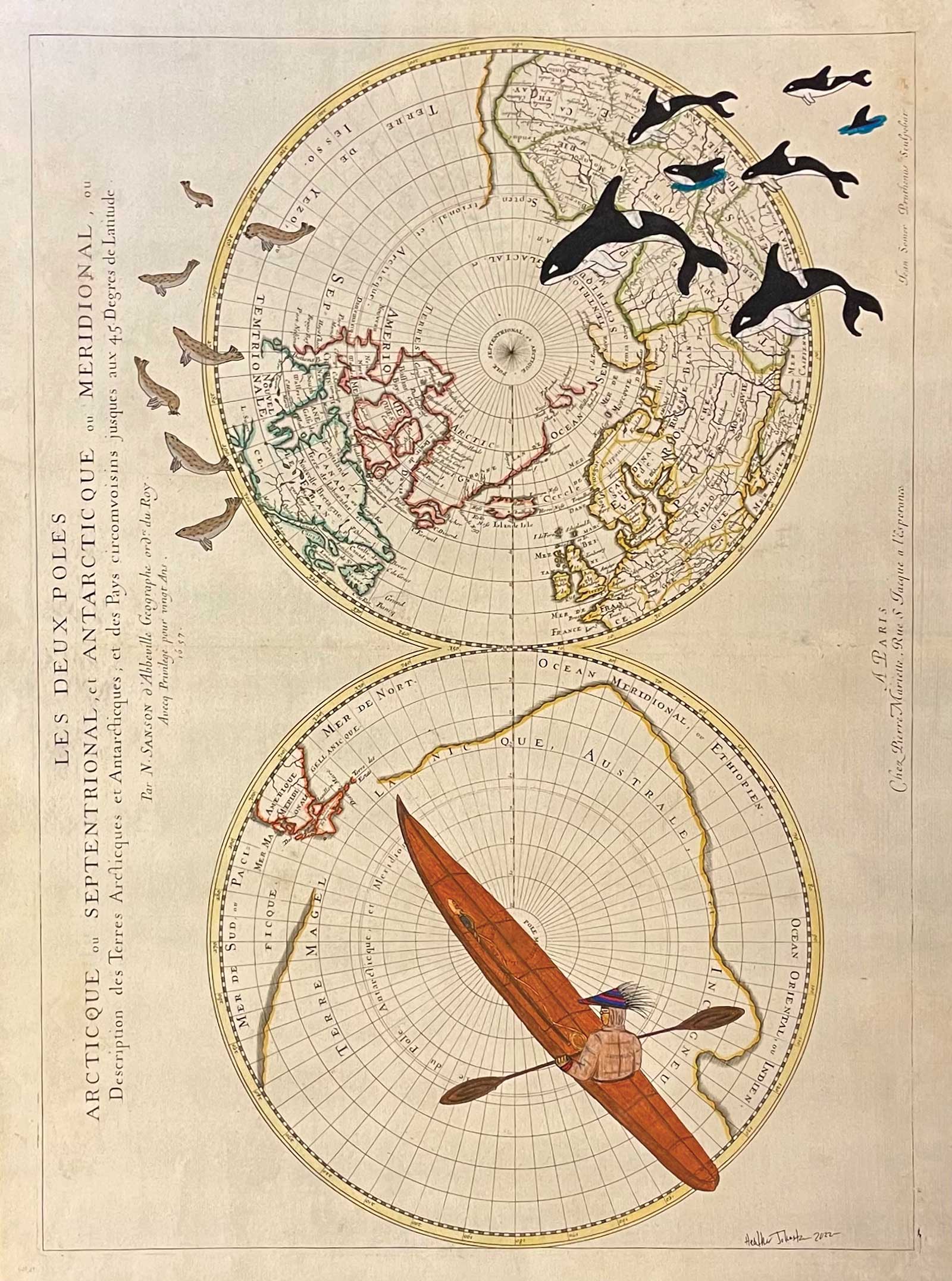
Heather Johnston (Unangan Alutiiq), First to Arrive, on Sanson’s 1657 map of the North and South Poles, 15 x 21”
Johnston’s work is titled First to Arrive and it was created on Sanson’s 1657 map of the North and South Poles. The artist says it has several meanings. “It represents the land that the Alaska Natives originally occupied,” Johnston says. “The second aspect of the piece is the Aleut hunter and the killer whale both hunting in a race for the same prize. I have always been drawn to antique items my whole life. I feel like it connects us to the past as well as our ancestors. So for a brief moment I feel like I am a part of the past.”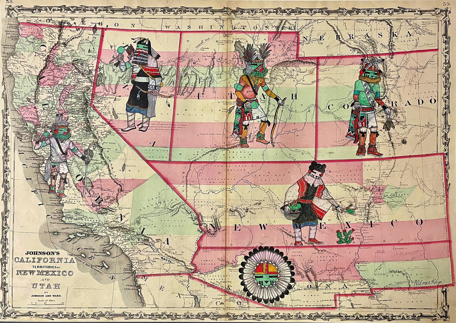
Wilmer Kaye (Hopi), Dawa and Rain Bringers Align the Desert, on Johnson’s 1862 Southwest region map, 16 x 25”
Clarkson will be presenting A, Chahta Sia (Yes, I Am Choctaw), on Buchon’s 1825 map of Mississippi. Inspiration for her work came immediately after seeing the map. “The Chahta women painted on this antique document symbolizes the importance of blood percentage and how it has shaped Native American people. Most tribes require a specific percentage of Native blood in addition to being able to document which tribal member they are descended from. Some tribes require as much as 25 percent, and most require at least 1/16th, which is one great-great-grandparent. Because of this policy, few if any Native Americans—regardless of upbringing in rural, reservation or urban settings—ignore their own and other Indians’ blood quantum in everyday life. In fact, my tribal identification card lists not just my name and photo but what percentage of my blood is considered Choctaw. This card must be produced to allow me to be considered a Native American artist,” Clarkson says. “This original document, written in French, chronicles the history of ethnic populations (termed as ‘white and people of color’) in the Mississippi area from 1600 to 1800. During this time the Native population from this area was moved to Oklahoma and other western territories. The government agents would declare incompetent certain ‘full bloods,’ thereby denying them allotment payments for land taken from them. At the same time, the agents declared other Indians ‘disqualified’ for payments due to their being mixed blood. In 1906, the Burke Act authorized the Secretary of the Interior with the official power to issue land to allottees considered competent and capable but deny land to those determined ‘incompetent’—a direct result of blood quantification.”
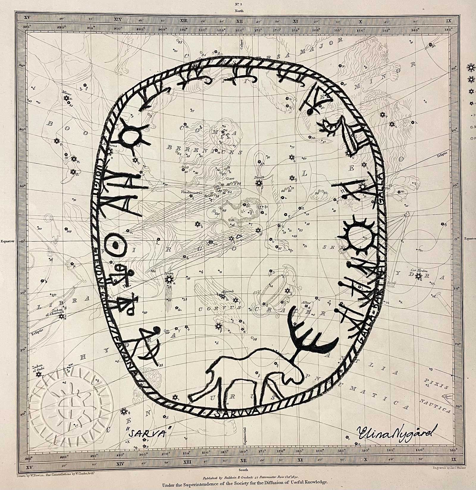
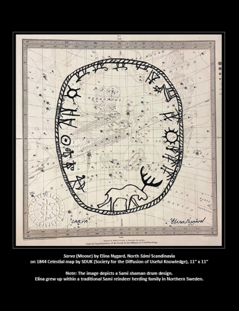
Elina Nygard (North Sami (Sweden)), SARVA (The Sami’s ‘Moose’ Shaman Drum), on SDUK’s 1844 Celestial map, 11 x 11”
Clarkson continues: “A, Chahta Sia declares ‘Yes, I am Choctaw,’ while acknowledging the dual aspect of tribal identity and blood quantification.”
The Homeland Collections will remain on view through June 1.
March 25-June 1, 2023
The Homelands Collections
Raven Makes Gallery, 182 E. Hood Avenue, Sisters, OR 97759
(541) 719-1182, www.ravenmakesgallery.com
Powered by Froala Editor